


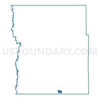
Barnesville City W-3, Clay County, Minnesota
About
Outline

Summary
| Unique Area Identifier | 601560 |
| Name | Barnesville City W-3 |
| County | Clay County |
| State | Minnesota |
| Area (square miles) | 1.23 |
| Land Area (square miles) | 1.23 |
| Water Area (square miles) | 0.00 |
| % of Land Area | 100.00 |
| % of Water Area | 0.00 |
| Latitude of the Internal Point | 46.64461280 |
| Longtitude of the Internal Point | -96.41974370 |
Maps

Graphs
Select a template below for downloading or customizing gragh for Barnesville City W-3, Clay County, Minnesota


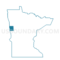
Neighbors
Neighoring Voting District (by Name) Neighboring Voting District on the Map
- Barnesville City W-1, Clay County, MN
- Barnesville City W-2, Clay County, MN
- Barnesville Twp. Voting District, Clay County, MN
- Humboldt Twp. Voting District, Clay County, MN
Top 10 Neighboring County Subdivision (by Population) Neighboring County Subdivision on the Map
- Barnesville city, Clay County, MN (2,563)
- Humboldt township, Clay County, MN (275)
- Barnesville township, Clay County, MN (147)